digest | Robotic sail-drones tracking the globe with on-board sensors
October 1, 2019

image | above
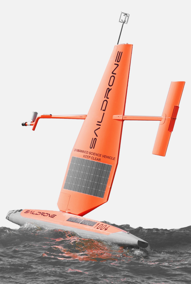
An autonomous sail-drone navigates the ocean using wind power + solar power.
photo: by SailDrone
— contents —-
~ story
~ infographic
~ featurettes
~ reading
~ definitions
— story —
SailDrone makes wind powered + solar powered ocean drones to understand planetary systems affecting humanity. The company designs, manufactures, and operates their global fleet sail-drones — monitoring the state of the planet in real time.
Their data sets can be used by commercial enterprise, research institutions, or private groups on specific missions. SailDrone is making world history by offering high resolution, ocean data collection at-scale.
Their sail-drone is 20 feet long, 18 feet high above the water, weighs 600 pounds. It can operate indefinitely: the wind is propulsion that pushes it along, a solar power panel charges the batteries that run the on-board computers + communications equipment.
The sail-drones navigate automatically using GPS, a system that uses space satellites to map the Earth. The craft is completely submersible and designed to handle the harsh effects of salt water.
Revolutionary benefits.
The sail-drones can autonomously travel 1,000s of miles: taking measurements of wind speed + wind direction, temperature, humidity, radiation, salinity, chlorphyll, pH level. Scientists in marine biology are using SailDrone’s fleet to monitor the Earth’s ecology + fisheries — tracking factors affecting food and climate for sea life.
In the past, researchers relied on data collected by large ships that cost $10,000+ per day to operate. Also, large ships can only approach shallow water of at least 66 feet. But sail-drones can travel into waters close to shore — as shallow as 10 feet — and continue to take measurements.
Another benefit is that sail-drones can stay afloat in rough weather, continuing to function — sailing the oceans without stopping for 12 months at a time. But big ships must avoid extreme storm weather or dock at shore — re-routing and interrupting science + commercial ocean missions.
Some missions to gather critical data have time-dependencies. So if the vessel is stalled for crew needs, mechanical break-down, or hazardous weather — the data can’t be collected on-time to solve problems. By comparison, sail-drones provide a reliable tool to gather essential information about the planet’s oceans and weather — in any season.
Because sail-drones are un-manned — the vessel has no crew, and doesn’t require a manned escort vessel — the sail-drones can travel into distant, inhospitable climates where people cannot.
The company is launching a project to send its sail-drones directly into hurricanes to better understand: where a storm will travel, how strong it will become, and when it will touch land. SailDrone plans to deploy 1,000 sail-drones for full global coverage — with the goal to have as much or better data of oceans than we currently have for land. That will transform our understanding of Earth.
Ocean data sets.
SailDrone offers global ocean data sets — on-demand + in-situ — for an area and time-frame at an unprecedented high resolution. The sail-drones collect planetary data: meteorological, oceanographic, bathymetric, acoustic.
This fleet of un-manned surface vehicles (called USVs) has traveled 500,000 nautical miles, carrying payloads of atmospheric + oceanographic sensors. Over many missions they’ve produce a series of large-scale data sets — describing parts of the world’s oceans that have never been covered in such detail.
Specialized missions.
SailDrone offers fully managed ocean data collection services anywhere in the world. The autonomous ocean drones stream real-time data back to shore.
The mission-as-a-service platform provides a dedicated fleet of sail-drones to affordably collect oceanic data + atmospheric data over extensive areas — and extended periods of time. A single mission can cover 10,000+ miles and last 12 months. Each vehicle follows a mission plan, autonomously navigating from waypoint-to-waypoint.
The fleet is outfitted with scientific electronic instruments to gather data — but that core sensor suite can be enhanced with additional, specialized sensors. For example, the sail-drone can carry an echo-sounder sonar to visualize underwater topography and fish populations.
Global weather forecasting.
SailDrone offers high resolution weather forecasts, enhanced by global ocean drone observations, delivered with mobile + web apps. Because better data means a better forecast.
The fleet of sail-drones continuously criss-crosses the planet collecting atmospheric data + oceanographic data to power a forecast model better than traditional inputs.

on the web | pages
SailDrone | home
SailDrone | technology
SailDrone | missions
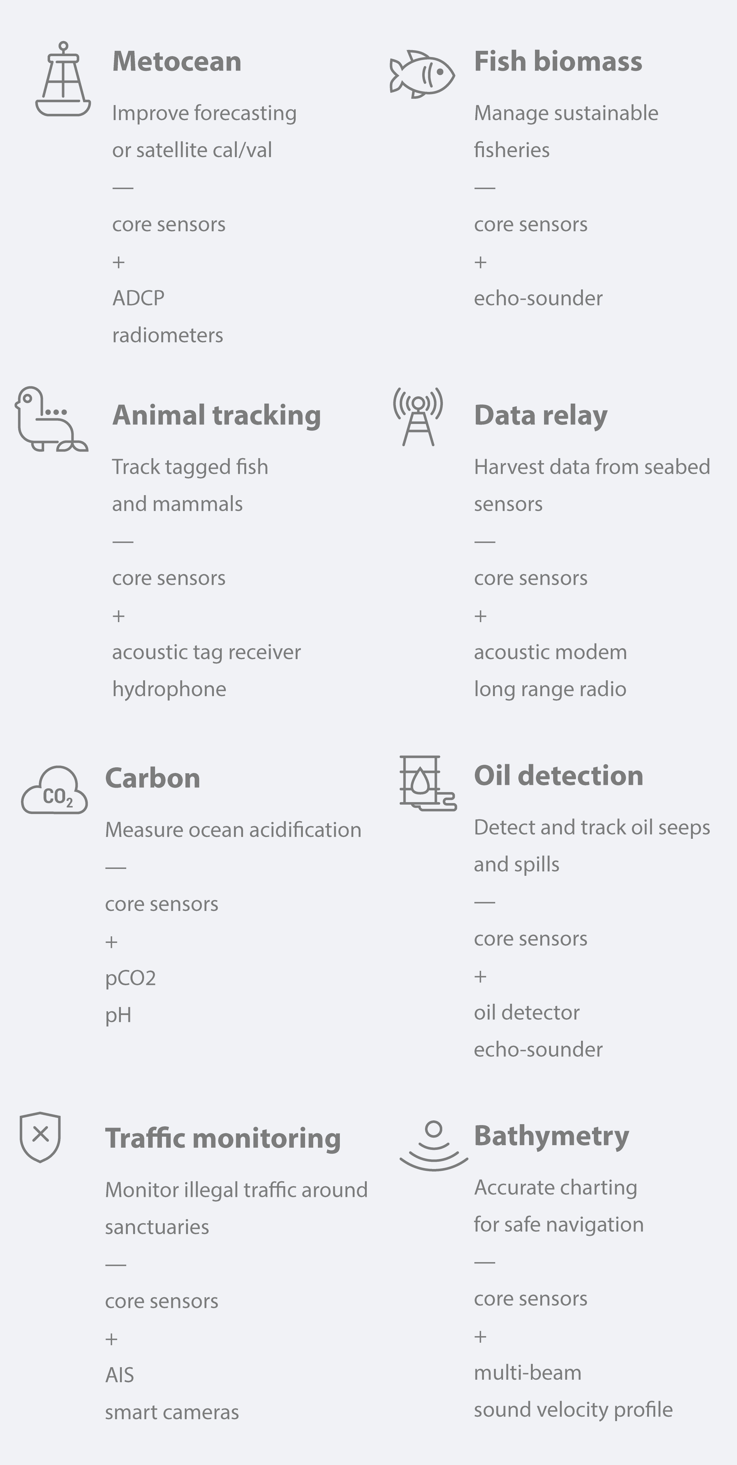
infographic | sail-drone sensor suite
The sail-drone’s on-board payload can hold many types of electronic sensors for science investigation and commercial projects. Below is a table showing a range of options offered by SailDrone.

watch | featurette
broadcast: BusinessWeek • by Bloomberg
series: Hello World
episode title: The robots roaming the high seas
season: 1
episode: no. 13
year: 2018
host: Ashlee Vance
watch | featurette
— summary —
Intelligent, indestructible, and with no humans on-board: these sailboats are plotting their own course through the oceans. If founder and CEO Richard Jenkins gets his way, soon there will be 100s of them –– trawling the oceans for data.
on the web | pages
BusinessWeek • by Bloomberg | home
BusinessWeek • by Bloomberg | series: Hello World
Bloomberg | home
Bloomberg | series
Bloomberg | YouTube channel
on the web | pages
Ashlee Vance | home
on the web | watching
NOAA | home
NOAA | featurette: sail-drones cutting-edge technology for ocean research

on the web | reading
publication: Science • by AAAS
story title: Fleet of sailboat drones could monitor climate change’s effect on oceans
read | story
publication: Wired
story title: The drone that will sail itself around the world
read | story
by definition | escort vessel
An escort vessel is a manned (with human crew) ocean ship that travels along-side another marine craft for protection, navigation, mission support, emergency management, or ceremony.

by definition | time-dependent information
Many activities in life require data — or information — for planning, understanding, exploring, mapping, modeling, and deciding between choices. How do we get data about anything? We must collect it, and that’s not always easy.
In science, we use powerful electronic tools designed to seek-out and track the properties of physical things, processes, and behaviors that researchers are looking at. In society, we track information about our human civilization’s activities, such as: building, manufacturing, transportation, lifestyle, health care, agriculture. That data is recorded on paper — and in modern times stored digitally.
When people need data to plan an activity, make a decision, understand a trend, answer a science question, create a solution to a problem — the quality and scope of the data matters. How much information do you have? And how recent / fresh is your information? Is your information showing the right perspective? Does your information show you a picture at the right time and place?
That’s where the term “time-dependency” comes in. In order for people to see clearly, whatever they’re studying, they need good data without errors, recording the right measurements — and for the right time-frame. Plus they need it “on-time.” Data has to be collected within enough time to be useful to your project or inquiry. It has to reflect the time period you’re researching, to be usable at all. If data is out-of-date, or arrives too late, it can botch a scientist’s calculations, give wrong conclusions, mis-lead developers, and fail to give you a full view. If the data you’re looking it is incomplete, it can throw-off your activities, projects, and plans.
That’s why reliable data sources are so important to humanity’s progress and to the planet’s ecology. The best data collection and measuring tools get good information to you when you need it, and without large chunks missing the points you’re looking for. Over an extended period of time, a complete picture should not have data gaps. And when you need information in an emergency — data arriving on-time can affect life or death, or equal success or failure.
So time-dependent information generally means:
- It means that data has to be collected at specific times, and track the right time period, to be useful.
- It also means that data has to arrive on-time to be helpful.
- It means that in mission critical situations, data arriving on-time is essential to a good or safe outcome.
If your activity requires time-dependent data, it means your plan or project is fundamentally depending on: a set of data to arrive by a deadline, and include recent data, or data from a specific time period.
And if that data doesn’t, there could be serious consequences. For emergency response, data about: an injury, epidemic, forest fire, animal or plant die-off, extreme weather, military or political crisis, crime — can be life-saving if it arrives on-time. Or result in catastrophe if it doesn’t.
IMAGE
— notes —
USV = un-manned surface vehicle
cal / val = calibration / validation
ADCP = acoustic Doppler current profiler
AIS = automatic identification system
CO2 = carbon dioxide
GPS = global positioning system
pCO2 = partial pressure of carbon dioxide
pH = potential of hydrogen
NOAA = National Oceanic + Atmospheric Administration • United States
AAAS = American Association for the Advancement of Science
